
Erosion and Sediment Control Field Guide
Standards Covered in Field Guide
Construction Site Diversion 1066
Temporary Grading Practices 1067
Stone Tracking Pad & Tire Washing 1057
Silt Fence 1056 Vegetative Buffer 1054
Non-Channel Erosion Mat 1052
Seeding for Erosion Control 1059
Mulching for Construction Sites 1058
Channel Erosion Mat 1053
Land Application of Anionic Polyacrylamide 1050
Storm Drain Inlet Protection 1060
Ditch Check 1062
Standards Not Covered in Field Guide
Sediment Basin 1064
Dust Control 1068
Water Application of Polymers 1051
Sediment Trap 1063
Turbidity Barrier 1069
Silt Curtain 1070
Erosion and Sediment Control for Building Construction Sites
Phase II of the Federal Clean Water Act has impacted all soil disturbances of one acre or more. The Department of Natural Resources (DNR) has developed performance standards for runoff from construction sites. The solutions that provide a method to achieve the level of performance required are found in Standards Oversight Council (SOC) Technical Standards. These SOC Technical Standards are found at:
http://www.dnr.state.wi.us/org/water/wm/nps/stormwater/techstds.htm
The SOC Technical Standards included in this field guide are the replacement for the “Blue Book” referenced in both the Commercial Building Code and the Uniform Dwelling Code.
If you have questions concerning this publication or the interpretation of the standards, please contact DSPSSBPOWTSTech@wisconsin.gov
Questions for Every Site
Is the erosion control plan being implemented?
Is the plan effective as installed?
Are soil stockpiles protected?
Is there no evidence that water is getting around or under the installed practices?
Maintenance conducted as per plan?
Repairs to practices completed?
Code violations involving erosion control are based on:
SPS 321.125 of the Uniform Dwelling Code
SPS 360 of the Commercial Building Code
All questions posed in this field guide require a “yes” answer to comply with the requirements of the SOC Technical Standards.
*means this is a consideration in the standard
Construction Site Diversion - 1066
Diversion discharges to stable outlet or channel?
> 2 ft top width?
< 2:1 side slopes?
> 1.5 ft high?
Not over-topped after 2-yr, 24-hr storm?
Stabilized prior to downslope disturbance?
Overflow area rip rapped?*
Sediment accumulation < 1/2 height of berm?
Temporary Grading Practices - 1067
End of day directional tracking?
Tilled < 15 in. apart ridge & furrow?
Temporary ditch sumps in drainageways?
Temporary ditch check 1/2 yd3/1% grade per 500 ft?*
Failure doesn’t threaten health or property?
Stone Tracking Pad & Tire Washing - 1057
Tracking pad or gravel mulch installed?
Tire washing stand if pad/mulch is ineffective?
Pad > 50 ft long and full width? Gravel mulch to structure?
Pad >12 in thick of 3-6 in. washed, clear stone?
No surface H2 O flows through tracking pad?
No unprotected exits?
Aggregate does not need replacing?
Saturated soil:Type R geotex. fabric under pad?
Silt Fence - 1056
Diversion discharges to stable outlet or channel?
Not installed in concentrated flow areas?
Not installed below H2 O or in channels?
Slope gradient is < 50% (2:1)?
Standalone practice on slope per Table 1?
Table 1 | |
Slope | Fence Spacing |
<2% | 100 feet |
2 to 5% | 75 feet |
5 to 10% | 50 feet |
10 to 33% | 25 feet |
>33% | 20 feet |
Silt fence parallel to contour lines?
“J hook” constructed in end of fence?
Height 14 in - 28 in above finished grade?
Post spacing < 3 ft non-woven, < 8 woven?
Support cord in silt fence?
Wrapped joints or overlapped?
> 20 in bury depth of posts?
Stakes on the downhill side of fence?
Sediment < 1/2 of fence height No torn or degraded fence?
Support posts correct?
Wood - > 1 1/8 in square, hickory or oak
3 ft long for 24 in silt fence
4 ft long for 36 in silt fence
1/2 in staples
Stapled in 3 places
Steel - 5 ft long, attached in 3 places
Attached with tie straps or wire
Sharp ends away from fabric
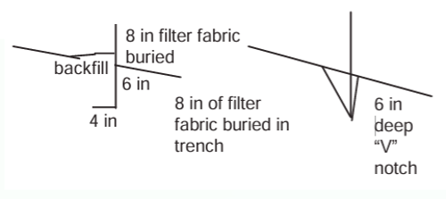
Buried as shown in diagram?
Vegetative Buffer – 1054
Used only for sheet & rill erosion control?
Buffer across entire downslope of area?
Buffer located on the contour?
Buffer slope < 5%?
Upslope disturbed area < 6% slope?
Width adequate (25 ft/125ft and +1 ft/5 ft)?
Buffer marked and undisturbed?
Buffer adequately vegetated?
Non-Channel Erosion Mat - 1052
PAL approved?
Upslope edge of mat trenched in?*
OK per erosion control matrix in PAL?
All seeding, fertilizing, etc under mat?
Mat has complete contact with soil?
No eroded areas under mat?
Checked manufacturer’s instructions?
Seeding for Erosion Control – 1059
Topsoil depth 2 in for temporary seeding?
Topsoil depth 4 in for permanent seeding?
Rocks, twigs and foreign material removed?
Clods < 2 inch? Seed sown < 1/4 in deep?
Temporary species and rates per table?
Species | Lbs/Acre | % Purity | Season |
Oats | 131 | 98 | Spring and Summer |
Cereal Rye | 131 | 97 | Fall |
Winter Wheat | 131 | 95 | Fall |
Annual Ryegrass | 80 | 97 | Fall |
Mulching for Construction Sites - 1058
Area under mulch free of gullies and rills?
Mulch not in concentrated flow channels?
Erosion occurring in mulched areas?
Natural biodegradable materials?
Free of toxic, noxious or diseased substances?
Marsh hay only on upland sites?
Crimped straw or hay fiber length > 6 in.?
No bark or wood chips on seeded sites?
Mulch covers 80% of unseeded areas?
Mulch covers 70% of seeded areas?
Mulch 1/2 to 1-1/2 in thick in seeded areas?
Mulch 1-1/2 to 3 in thick for unseeded areas?
Wood chips 1/2 to 1-1/2 in thick?
Mulch anchors w/crimping, matting and tackifier?
Channel Erosion Material – 1053
PAL listed materials?
Class II or III material?
Installed after seeding, fertilizing etc.?
Continuous, firm contact with soil?
Anchored per manufacturer’s requirements?
TRM w/topsoiling & followed by ECRM?
Extend > 1ft vertically from ditch bottom or > 6 in above design flow (whichever is greater)?
Erosion Control Land Application of Anionic Polyacrylamide – 1050
Slopes < 2.5: 1?
Not applied to channel bottoms?
Used as approved in the PAL?
Storm Drain Inlet Protection – 1060
Emergency spillway?
Fabric per PAL?
Correct Type (A,B,C,D)?
Ditch Checks – 1062
Not located in stream?
Weir formed in center of ditch check?
> 2 ft top width 2:1 maximum slope on sides of ditch check?
1 ditch check per 2 ft channel drop?
3 in graded annular stone? or PAL listed?
Erosion mat at base? Stone chinked or sealed?
10 - 16 in high (mfg. or bio.) or 36 in high for stone?